
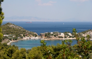
Andros is mountainous and it is criss-crossed with a number of mountain ridges. All of these ridges run parallel to one another from southwest to northeast. Between the ridges there are deep valleys and sometimes steep gorges. The highest summits are the Kouvára (with the Profítis Ilías at 997 m) and the Pétalo (990 m), in the centre of the island, between the towns of Ano Aprovátou and Vourkotí. Because of this relief the north-south connections on the island are rather difficult. Except for the main coastal road, most of the roads thus run into the valleys, from the southwest of the island to the northeast.
Andros is a unique island for a number of different reasons. First of all, in comparison with many of the other Cycladic isles, there is a lot of water – and this thanks to the relative high amount of rainfall and the multitude of sources. As a result, some of the valleys are remarkably green. Especially the pine tree dominates the landscape (for instance in the neighbourhood of Ménites). There are also lots of remnants of watermills in the valleys of the Dipotámata (between the towns of Exo Vouní and Sinetí), in the valley of the Mégalo Révma (in the north), etc.
The second remarkable characteristic is the architecture of some of the villages, which is not really Cycladic. Andros is a very wealthy island and this is partly the result of generations of ship owners. The villages of Chóra and Steniés are therefore striking because of the large and wealthy houses. The red roofs resemble the Italian cities and also some Greek islands such as the island of Sími near Rhódos.
To read more, please visit cycladen.be
BUSINESS CENTRE

XpatAthens
Andros
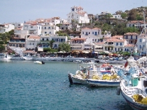
Andros is the northern- most island of the Cycladic isles. The islands of Kéa, Kýthnos, Sérifos and Sífnos can be seen as a natural continuation in the sea of the peninsula of Attika; in the same way, the nearby islands of Andros, Tínos and Mýkonos can be seen as the foothills of the mountain ridge of the island of Evia (Euboia).
Areopolis
The town is of great historic importance to Greece as it was here that the war for independence against 350 years of Turkish occupation began. On 17th March 1821, a banner was raised and allegiance sworn under the motto “Victory or Death” by the various Maniat clan leaders assembled. They then marched to Kardamyli and on to Kalamata. The seven-year struggle had begun. In recognition of this role, the town was renamed Areopolis after Ares, the god of war, in 1836.
Previously it had been known by its Slavic name, Tsimova.
In the last decade Areopolis has seen something of a boom. The central square, dominated by a statue of Petrobey Mavromichalis, has been repaved, a new police station and town hall built, a number of new bars and cafes have opened along with hotels to accommodate visitors and on the outskirts of the town are a number of recently built, huge stone shops and supply yards. However it has by no means lost its quality of an atmospheric gateway into Mesa Mani and no tour of Mani is complete without stopping here. At the very least it warrants a coffee stop or lunch. The main square is the centre of life in the town and is a great place to ‘people watch’.
There is a market every Saturday, mainly selling fruit and vegetables, turning the square into a hive of activity. However, Areopolis deserves a little more time. Its narrow alleys and cobbled streets are a photographer’s dream and, being a historic town, there are a number of places worth visiting. There is a great bookshop on the square, next to the cake shop. Its owner, Georgios, is a real Mani enthusiast and has a good stock of maps, books and recently a DVD as well as his own Mani magazine (in Greek). A Byzantine museum is located in the restored tower next to the church of Ioannis O Prodromos. It promises to ensure that local treasures housed in locked churches will now be on permanent display beyond the grasp of unscrupulous thieves.
By following the map out of Areopolis on the road to Omales, it is possible to walk down to the pebbly beach of Pyrgos and then on the caves of Pyrgos Dirou. Once you come to the T-junction marked on the map of Areopolis, simply turn left and follow the road all the way down to the beach. The concrete gives way to a dirt road and as you near the sea, it swings right. To get to the beach you have to hop over the wall by the house and walk down some steps to get on to the rocks. You will see steps ahead of you on the other side of a very small beach that bring you out onto the tarmac road to the beach. It should take just over an hour to here from town. There is no café on the beach so you will need to take plenty of water. It is also possible to cut across the small headland at the far end of the beach to get to the caves of Pyrgos Dirou. An earth path runs around the back of the concrete hut – simply follow it for 5 minutes to get to the caves. The ticket office is 100m up the road.
Source: Insidemani.gr
5 Greek Islands You Need To See
You’d be forgiven for thinking the Greek islands were invented for tourists. Though tranquil, idyllic and remarkably quaint, it was only relatively recently that places such as Mykonos, Santorini and Corfu became destinations for everyone from celebrities to honeymooners. Even mainland Greeks did not vacation in the islands until a few decades ago.
Now the islands have become some of the world’s most recognizable tourist destinations. Most visitors flock to the same handful of places every year but there are hundreds of islands to choose from, many of which have maintained their village life. Here are five off the well-worn tourist track...
Folegandros
When an Athens travel agent told me to visit Folegandros I was skeptical. It was late July and boats to other islands were sold out. I hadn’t heard of Folegandros and had to be shown it on a map but I booked anyway. It turns out that was the best decision I’d make that summer. Folegandros is a hidden gem in the Aegean, with a cliff-hanging whitewashed village (known locally as hora), rugged but stunning landscapes and beaches hugging the side of high promontories. Visitors are mainly Greek with a smattering of French and Italians. The sleepy town wakes up in the night with tables spilling into the cobblestone streets filled with multilingual diners. Breakfast or dinner in the courtyard of Mimi’s restaurant is almost surreal in its charm.
Patmos
In 2009, Forbes magazine proclaimed Patmos the most idyllic place to live in Europe. It’s hard not to see why. The island coastline rolls and swirls forming bays and inlets with crystal blue water. Patmos is dominated by the imposing Monastery of St. John the Theologian under which is the cave where John wrote Revelations. The spiritual island has numerous beaches and a surprisingly vibrant nightlife for a place where monks make up a good portion of the population. George’s Place at Kambos beach is a good spot to get a drink while soaking up the sun. A visit to the three historic windmills, recently restored by a Swiss banker who vacations on the island, is a must.
Anafi
Anafi is stunning, but chances are you’ll overlook it once you realize how time consuming it is to reach. There’s no airport and it’s a 10-hour ferry ride from Athens . The population? Less than 300. Those who make the journey are rewarded with the island’s remoteness, serene beaches and its enchanting white cubist village that tumbles down from the mountains. The footpaths around the island linking the various settlements make it a perfect place to hike during the early morning or at dusk when the sun is not so strong. Take a tour through the island’s history on a hike from the hora (main town) to the 8th century BC ruins of Kastelli to the monastery Panagia Kalamiotissa built on Apollo’s temple. It also offers gorgeous views of the coast.
Samos
Popular with northern Europeans, Samos is one of Greece’s greenest islands known for its Muscat wines. Samians are undeniably proud of the their export and never forget to insist that it’s not just for drinking with dessert. Vineyards roll up and down the hillsides of Samos right down to the sea and can be visited on an informal basis. The Viticultural Union of Samos’ museum is a great place to taste the wines and learn more about the island. Samos is large and meant to be explored by car, which are easy to rent here. Stay in the picturesque port of Pythagorio with its shiny cobblestone streets and bustling, popular waterfront. The fish restaurants on the far left of the port are the best. The capital Vathy is mostly devoid of tourists but worth exploring on a Friday night when locals dine and stroll along the harbour where working fishermen (and women) tend to their vessels and string nets.
Samothraki
Steeped in mystery and lore, Samothraki is one of Greece’s most magical islands. With no natural harbour and no airport, it is mostly visited by northern Greeks – and, according to legend, witches. Rumour has it that the island is frequented by sorcerers and other practitioners of the dark arts, due to its ancient reputation for pre-Hellenic cults and its more mysterious atmosphere compared to the white-washed, austere islands in the southern Aegean. Whether that’s true, the island, once described as “taciturn” by author Lawrence Durrell, is lush and mountainous with hidden waterfalls and tropical vegetation. Towering Mount Fengari hovers like a dark cloud over the north Aegean from the Greek mainland and offers impressive views – if you’re up for a hike. The island is also home to the Sanctuary of the Great Gods, a pre-Hellenic and Hellenic historical site where the famous Winged Victory of Samothrace statue, now in the Louvre, once stood.
To read more, please visit The Globe and Mail
By Alexander Besant
Papigo Village, Zagoria
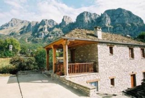
The village of Papigo is situated on Astraka, one of the highest peaks of Mt Tymfi, alias Gamila. It is 62 km far from the city of Ioannina, and is thought to be one of the most beautiful villages of Zagoria. It is on the North side of the Vikos gorge and can be accessed by crossing the Voidomatis River bridge. Then you must take the road up in order to arrive to one of the two districts Papigo village is divided into, Megalo and Mikro.
The road leading to the village of Papigo is a feast for the senses.
The feature of this road, crossed by the Voidomatis River, is picturesque, creating great natural scenery that attracts the visitor’s eye. The view of the Vikos gorge is also stunning. However, if you drive, it is important to pay attention on the road, because it is narrow and very zigzagging. Once in Papigo, great strolls around its stone-alleys can be held, as its two-stored mansions have been declared a national historical monument. Their construction materials are mainly stones. In fact, this is the main material on the village and is used almost for everything. These constructions are also unusual because they do not have a balcony.
Another interesting point is the natural fountains –also made of stone, located close to the village. They are ideal for refreshing in the hot days. Another interesting activity that can be held in Papigo, more specifically in Megalo Papigo, is to visit the personal library of Micheal Anagnostopoulos. It includes around 1250 volumes of books –most of them in foreign languages, published between 1750 and 1906.On the other hand, Mikro Papigo is 3 km further up after Megalo Papigo. It is amphitheatrically built on the steep slopes of the mountain and leads to the popular Dragon Lake, placed on the edge of a great limestone cliff overlooking the Aoos Valley.
To read more, please visit greeka.com
Limnos: The island of Hephaestus
The tasteful thyme honey and the fresh fish are also some of the great gifts of nature to the lucky island.
The history of Lemnos is lost in the mists of time. According to mythology, Hephaestus had his forge on the island and taught its first residents, the Sinties, the art of processing copper. The Island flourished during prehistoric times. In 512BC it was conquered by the Persians, but it regained its liberty after the end of the Persian Wars. Since then, it had been subjugated consecutively by the Romans, the Venetians and the Turks, until its definitive liberation in 1912 during the 1st Balkan War.
Capital of the island is Mýrina, a town beautiful for its traditional paved alleys, its old stone mansions, its promenade by the sea, and last but not least for its Byzantine Castle. The impressive castle that overlooks the town lies on a rocky and steep peninsula, on the hillside of which small deer roam free.
Touring around the island is as much an enviable experience as choosing only some of its beauties to write about is a nasty task. Still, a visit to Lemnos is not complete without having been to:
• The Petrified Forest near the town of Moudros, where one has the chance to see fossilised trunks, leaves, fruit and palm-tree roots aged 20-22 million years.
• The prehistoric settlement of Poliochni which is thought to be the oldest Neolithic city in Europe. Actually, a rectangular building with a double row of stepped seats that had been found on the site resembles a parliamentary architectural structure; that’s why it is presumed to be the oldest parliament discovered in the world!
• The archaeological site of Hephaestia, the prehistoric capital of the Pelasgians, whose glory days lasted well over 2000 years (1000BC to 1200AD). Admire the ruins of a complex of a city built and rebuilt in 10 layers, including palaces, baths, Christian churches, a Hellenistic-Roman theatre, a necropolis, and a sanctuary dedicated to the great goddess Lemnos.
• The two small lakes Alyki and Chortarolimni which constitute wetland habitats, refuge and breeding places for rare and endangered bird species.
• The ideal for skin conditions and urinary system problems thermal springs of Hephaestus, at only 4km from Mýrina.
• The waterfalls near the village of Káspakas, where the waters rush off a height of 15m to create an appealing natural site dotted with small plateaus and tiny ponds.
• The village of Kontiás, one of the biggest and most beautiful ones, which is built on a pine-clad hill and is decorated by traditional stone houses, deserted windmills, and the picturesque church off Ághios Dimitrios with the stone bell tower.
• The gorgeous sandy beaches of the islands, which range from peaceful, remote, romantic to busy and well-organised ones. Especially the water sports lovers will go crazy for the beaches of Thanos, Gomati (treat yourself with the pleasure of rolling on the sand dunes there) and Keros, with the last one being a well-known centre for aquatic pleasures and sports activities. Nevertheless, the repeaters of the island and the locals would answer Platý or Chavoúli should they be asked to choose a beach to appear on a postal card from Limnos.
Source: Visitgreece.gr
The Beautiful Island Of Hydra
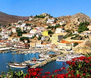
Hydra, built in the shape of an amphitheatre on a slope overlooking the Argosaronic gulf, is one of the most romantic destinations in Greece. Traditional stone mansions, narrow cobblestoned streets, secluded squares and above all the banning of cars and the use of around 500 donkeys as means of public transportation, explain the reason why Hydra preserved its distinctive atmosphere through the passage of time.
The island experienced exceptional economic growth in the past thanks to its great naval and commercial activity. The Hydriots contributed significantly also to the 1821 War of Independence as their powerful fleet participated in crucial sea battles. It is a rather impressive fact that such a tiny island is the birthplace of five Greek Prime Ministers!
Lavish stone mansions owned by important families (Voulgaris, Kountouriotis, Tombazis, Kriezis, Bountouris, etc), and built by Italian artisans reveal the wealth that experienced the island in the past. Today most of these mansions house the island’s museums. 300 churches and 6 monasteries spread around the island as well as the cannons and the statues of the Independence War heroes still standing at the balconies of the islands create a romantic mosaic.
As you walk along the waterfront, the heart of the town, you encounter monuments, churches, canons, museums, old mansions, statues of famous heroes, the old gunpowder store, shops and cafes, while picturesque winding streets lead you to neighborhoods located at the upper part of the town, as well as to the old neighborhood of Kiafas.
To read more, go to visitgreece.gr
Enchanting Chania - The Former Capital of Crete
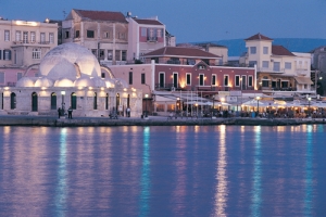
Chania (also spelled: Haniá) is the capital city of the Chania prefecture, a place where different civilizations have flourished throughout the centuries. Wandering around the Old Town’s maze-like alleys with the beautiful Venetian mansions, the fountains and the elaborate churches will help you discover well-preserved historical monuments.
The city of Chania is built on the area of Minoan Kidonia, at the end of the homonym gulf between Akrotiri and Onicha peninsulas. It was the former capital city of Crete (from 1847 until 1972). Nowadays, it is the second largest city of Crete after Heraklion and capital of the homonym prefecture.
Chania includes the old and new city. It is one of the most beautiful and picturesque cities in Greece and for food lovers, it's a paradise!
Get familiar with the city of Chania by wandering around in its streets, visiting its museums and admiring the different architectural styles presenting the historical route of the city.
After Arabs and Byzantines it was conquered by Venetians in 1252 and was given to Turks in 1669, later it was annexed to the rest of the Greek State on December 1913 under the administration of Eleftherios Venizelos and King Konstantinos the 1st. The old town is an integral settlement with visible boundaries set by the Venetian walls surrounding it.
To read more, please see visitgreece.gr
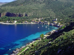
Vouraikos Gorge
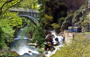
The Vouraikos gorge is a fantastic landscape of towering pinnacles and precipitous rock walls that you can view on an exciting train ride. In addition, a road goes directly from Diakofto to Kalavrita; the spectacular 25-km (15-mi) drive negotiates the east side of the gorge. Diakofto is a peaceful seaside settlement nestled on a fertile plain with dramatic mountains as a background; the village straggles through citrus and olive groves to the sea.
If you're taking a morning train up the gorge, plan on spending the night in Diakofto, maybe enjoying a swim off one of the pebbly beaches and a meal in one of several tavernas.
After dinner, take a stroll on Diakofto's main street to look at the antique train car in front of the train station, then take a seat at an outdoor table at one of the cafés surrounding the station square and enjoy a gliko (sweet). This is unembellished Greek small-town life.
The Kalavrita Express, an exhilarating narrow-gauge train ride, makes a dramatic 25-km (15-mi) journey between Diakofto and Kalavrita, which is a refreshingly cool retreat in summer and a ski center in winter. Italians built the railway between 1889 and 1896 to bring ore down from Kalavrita, and these days a diminutive train, a diesel engine sandwiched between two small passenger cars, crawls upward, clinging to the rails in the steeper sections with a rack and pinion, through and over 14 tunnels and bridges, rushing up and down wild mountainside terrain. Beyond the tiny hamlet of Zakhlorou, the gorge widens into a steep-sided green alpine valley that stretches the last 11 km (7 mi) to Kalavrita, a lively town of about 2,000 nestled below snowcapped Mt. Helmos. Greeks remember Kalavrita primarily as the site of the Nazis' most heinous war crime on Greek soil. On December 13, 1943, the occupying forces rounded up and executed the town's entire male population over the age of 15 (1,436 people) and then locked women and children into the school and set it on fire. They escaped, but the Nazis later returned and burned the town to the ground. The clock on the church tower is stopped at 2:34 pm, marking the time of the execution.
The Kalavrita Express makes the round-trip from Diakofto four times daily. The trip takes about an hour, and the first train leaves at 7 am. Comings and goings are timed so that you can do some exploring; in a day's outing, for example, you can alight at Zakhlorou, make the trek to Mega Spileo, continue on to Kalavrita, explore that town, and return to Diakofto by the last train of the day. Check with the EOT in Athens to make sure the train is operating—repairs can close the line for months at a time; the Chris-Paul hotel is another good source of information.
Source: Fodors.com
Salamina
According to the myth, the name Salamina (Salamis) was given to the island by Kychreas in honour of his mother Salamis, one of the five daughters of the river god Asopos. In Salamina you can visit the following museums and sights: The Municipality of Salamina Folk Art and History Museum: It host exhibits of the island’s history, including a collection of local costumes, furniture, agricultural tools, weapons and ceramic items.
The Maritime museum: An outdoor museum in the area of Paloúkia exhibiting cannons and torpedoes.
The Ancient port: The ancient port is located in the area of Ambelákia and dates back to the 4th century BC. The port contributed significantly to the economic development of the ancient city of Salamis. The famous naval battle of Salamis also took place here. Ambelakia is the oldest village on the island, 4 km south of Salamina, and it certainly worths a visiting!
Churches and Monasteries like Faneromeni Monastery, Ayios Nikolaos Kalyvitis and Ayios Dimitrios Church.
If you want to swim, visit the southern side of the island, where the beaches are cleaner. The most popular beaches are Selínia, Kanákia, Faneroméni, Saterlí and Kakí Vígla.
To read more, please see visitgreece.gr
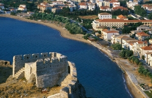
Gytheio
Gythio is located in middle south of Peloponese at the center of the Laconian Gulf. It is a lively, charming little harbour town. Most of its houses are two- or three-storey neo-classical mansions, stuck to the steep side of the Mt. "Koumaros". A long sea-side promenade, the colourful fishing boats, the narrow streets and stairways produce the typical Greek environment which fascinates every visitor.
There are not really mentionable ancient objects to be studied in Gythio. From its ancient past, only a small Roman theatre was left by an earthquake that destroyed the city in the 4th century. So, every visitor is free to just enjoy the Greek life of the present.
Gythio is protected by spurs of the mighty Taygetos mountain range. Its highest "Profitis Ilias", with 2.407 m the highest mountain on the whole Peloponese, makes a marvellous background scene. From November to May, the snow-white peaks are a magnificent sight behind the deep blue sea.
A little island called "Kranai" and connected with the mainlaind by a short dam, protects the port of Gythio town from the open sea. It is a beautiful place with pine-trees and an ideal view-point to overlook the gulf towards the Parnon mountain range in the east and Taygetos in the north-west. As it is reported by Homer, the island was the first refuge of Helen and Paris on their journey to Troy. According to the myth, Paris forgot his helmet on the islet as he was leaving - hence its name, since in Greek a helmet is calles "kranos". An interesting site on Kranai is the restored Tzannetakis Tower, a Maniot fortress-residence belonging to the Tzannetakis-Grigorakis families. It was donated to the state and currently houses the History and Ethnology Museum of Mani. Also worth visiting are the chapel of Agios Petros and the octagonal lighthouse of 22 m height, built in 1873 of tenarian marble.
There are many beaches around of Gythio and the largest one is Mavrovouni-beach. Because of its length of several kilometers it will never get crowded - just during the first half of August, when nearly all Greek people are on holiday, it may become a little more lively. In the afternoon, usually a perfect wind for wind-surfing will raise, and you can also hire a board and take lessons by the "Ocean Cafe". Mavrovouni beach is one of the favourite places for the "caretta-caretta" sea turtles to lay their eggs in the sand. The nests are surveyed and protected of the Sea Turtle Protection Society of Greece called ARCHELON.
In 2007 the beach of Mavrovouni was awarded the BLUE FLAG. The Blue Flag award is both based on all the bathing water quality results of the previous year and of the current year of the award. This means that only beaches with excellent bathing water quality standards in the previous year will be eligible for the Blue Flag award.
Source: Insidemani.gr