XpatAthens

XpatAthens

Wednesday, 18 February 2015 13:05

Knossos ~ The Mythical Ancient City

Knossos, is the largest Bronze Age archaeological site on Crete and is considered Europe's oldest city. Located 5 km southeast of the city of Heraklion in Crete, it is one of the most visited archaeological sites in Greece as the Palace of Knossos was undoubtedly the ceremonial and political centre of the Minoan civilization and culture.


Discover Greece through its fascinating art and history!
This article has been brought to you in cooperation with MuseumMasters.


Knossos was the seat of the legendary King Minos and the main centre of power in Crete. The Palace of Knossos is connected with famous myths, such as those of Daedalus and Icarus and the Labyrinth with the Minotaur.

The ruins of this majestic Palace are a source of world history and culture. The Palace was decorated with magnificent frescoes and continuous rows of spirals, dating back to 1600-1500 B.C. The murals depicted a variety of subjects performing scenes from the everyday life of the Cretans, such as the "Priest-King" or "the Prince with the lilies", which probably portrayed the Priest-King who lived in the Palace of Knossos.  The famous "Bull-Leaping" or the “Toreador Fresco” represented a sport that had a long tradition in the Minoan Crete.

Small scale sculpture art flourished in Crete as well, during this period of time. The famous "Goddesses of Snakes" from the Palace of Knossos, are some of the most important examples of this technique. These figurines, as well as the fresco of the "La Parisienne", depicting a stunning woman with big eyes, wavy hair and red lips, that was probably a priestess or a goddess, showed the luxurious and artful female clothing prevailing at that time in the Cretan society.

Visit the archaeological site of Knossos and see all the wonderful monuments of the largest and most brilliant centre of Minoan civilization. Walk along the ruins and feel all the exciting myths of Crete "come alive" in front of your eyes.
 

Visit MuseumMasters and enjoy an educational and inspirational shopping experience!


Wednesday, 18 February 2015 13:04

Karditsa Prefecture

One usually thinks of Greece as an archipelago of a lot of islands. Yet, Karditsa can surprise its visitors with mountain landscapes as dramatic as one can see in the Alps, just one of many places of incomparable beauty in this region. Lake Plastiras, lying in the magnificent valley of the Agrafa Massif, welcomes its visitors with hotels and hostels designed to merge with the natural environments, and also equipped to satisfy even the most demanding clientele.


Here you will be able to enjoy thoroughly unspoiled landscapes that have only recently attracted the attention of international Nature lovers.

Along the lakeside road, a series of pavilions and small shops invite visitors to savor the exquisite traditional tastes and fragrances of the region’s particular delicacies. Locally produced pastry and confections, wine, and other specialties await to introduce the traveler to the real joys of Karditsa Prefecture.

One occasion you would not want to miss is the Carnival manifestations in Sofades, a few kilometers away from the capital of the Prefecture. They take place in the beginning of spring, and they signal the end of winter, still visible in the snow-capped mountains and hills in the distance.

The lightheartedness of time is reflected in the morning smile of the lake. Now, the excursions in the region's lower mountains, to a series of breathtaking sites centered on Plastiras Lake or in the Town of Karditsa, are a real enjoyment; from historic Ellinopyrgos to the cool Kanalia and Fanari, where the well-preserved old castle dominates the plain below. Another trip, a short ten kilometers from Karditsa Town, brings us to Aghios Athanassios hill, where we can see the remains of the Byzantine castle, now ruined, built with the stones of the ancient acropolis of Kalithiros, known from Hellenistic times (3rd to 1st centuries B.C.). On our way back, Aghios Georgios Village and its church are worth a visit.

To read more, please visit windmillstravel.com

Wednesday, 18 February 2015 13:03

Patmos & The Monastery of St. John

The locked gates to one of the world’s most revered holy places are themselves imposing, looming high above the port of Skala on this island in the eastern Aegean. The St. John monastery was built by St. Christodoulos in 1088 to venerate St. John, who wrote the Book of Revelation in a nearby cave after being exiled to the island in 95 AD by the Roman emperor Domitian.

 Now home to 15 monks, the monastery is located at the highest point of Hora, which is a spiral of whitewashed buildings, many in varying states of graceful decay, perched dramatically over the port.

Visiting the monastery was my first order of business on Patmos and it did not disappoint. The church’s icons are visually arresting, the views of the surrounding islands are sublime, and the presence of black clad monks a reminder that St. John’s is a magnet for devout Christians.

Locals claim that Patmos has more than 300 churches, or one for every 10 residents. Father Ioustinianos, 62, a monk from Crete who has lived at St. John’s for 22 years. took me on a private tour of Zoodochos Pigi, an early 17th-century monastery in Hora, and invited me to an afternoon service at St. John’s.

To read more, please visit boston.com

By Dave Seminara

Wednesday, 18 February 2015 13:01

Sightseeing On The Island of Thassos

Thassos is believed to have been named after Thassos, the son or grandson of Aginoras, the king of Phoenicia. Thassos went to the island in search or Europe and he established himself there as its first king. Other ancient sources claim other names for the island, such as “Hieria”, by her chill summer breeze, “Athria”, by her clear sky, “Coast of Goddess Demetra”, by her fertile ground or “Dasos”, meaning forest in Greek, from the many forests on the island.

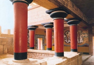
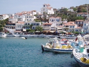
Thassos Ancient Town

Right next to Thassos town lay the remnants of Thassos ancient settlement which had two ports, the military one, closed to public and ships other than military ships, and the commercial one, used for the town’s commercial activities. The Agora, the cornerstone of politics, administration and economic activities is among the most important findings on the island. The findings number various statues, sculptures and inscriptions of great value most of which are exhibited today at the Museum of Louvre as the excavations that brought them to light was conducted in 1911 by the Archeological Faculty of France. The ancient Odeon and the ancient theatre, the sanctuary of Zeus and Artemis are also among the principal parts of the site.

Olives and Olive Oil Museum

Right outside the settlement of Skala Prinos is located this newly established and pretty interesting museum, paying a tribute to the miraculous products of olive trees! An initiative of a local bio-oil business, the museum hosts a space where a representation of oil production takes place, a photography exhibition space, a part where all types of oils are exhibited (around 40 from the 130 different types that are known up today), a projections’ space and finally the olive products exhibition, where you will be able to taste and buy anything you like!Kalogeriko

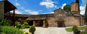
Kalogeriko is a historical building standing out from all the other buildings at the centre of the ancient port of Thassos. Is was built at the end of the 19th century and nowadays it hosts various cultural exhibitions and galleries of Greek and foreign artists. You should absolutely visit it and admire its architecture.

Potamia

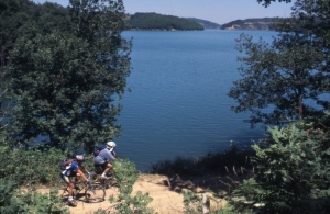
A small traditional village located on the eastern part of the island, very near Panagia and Chrisi Akti. Potamia is built on the foot of Mountain Ypsarion and it consists in beautiful small houses with stone walls and wooden roofs. Potamia is ideal for hiking as here exist various paths that enter the mountain in a scenery of lush vegetation and total serenity.

Kazavitia

The Small and Large Kazaviti (Small and Large Prinos) villages are found in the north central part of the island and are, without a doubt, among the most beautiful and picturesque villages of the island. Small and narrow stone paved alleys, stone built houses with wooden terraces and balconies and painted ceilings, the scenery here will definitely take you back in time. Though both of the villages have seen very glorious times in the past, when the inhabitants stayed and worked here, protected by the pirates that raged the lowland and seaside settlements, nowadays are rather abandoned. Still standing here are the remnants of an old school that contributed greatly to the island’s history, the old mansion houses and churches. The perfect place to relax in the sound of nature and running waters and have a lunch or coffee at the Large Kazaviti’s central square.
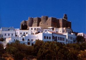
Kastro

On one of the tops of mount Ypsarion, right in the heart of the island, lies the oldest settlement of the island, Kastro (meaning “castle” in Greek). Its inhabitants were here protected from the pirates till most of them left the village to work to the mines of a foreign company and transferred their settlement at Limenaria. The village used to be the place where they spent their holidays but during the recent years many attempts to restore the village have taken place with remarkable results!

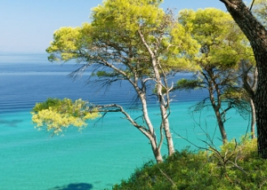
We could keep on describing the island’s magnificent villages but it would be better for you to explore them in person making sure you will not leave aside Panagia, Kinira, Astris and Themonia.

Source: Cycladia.com


Wednesday, 18 February 2015 12:57

Pertouli – A Quaint Mountain Village

Pertouli, built above the mountain slope, used to be a gathering place for farmers in the region. What makes the village special is its picturesque stone houses with red or stone roofs. The area is less tourist-oriented than Elati, with lesser but of a higher quality and style accommodation. It has a ski center which operates at the "Pertouli Meadows" with a relatively small track, which is suitable for less experienced skiers and it is equipped with ski-lifts.

Throughout the year you can also go horse riding, do archery, cycling and other mountain-related sports.

The forest near Pertouli is one of the most beautiful and well preserved fir forests in Greece. It is a refuge for wild animals, like deers, wolfs, bears and rare species of birds. The Aristotelio University of Thessaloniki has undertaken the tourist utilization and promotion of this forest.

Eighteen kilometers from Trikala to Arta, lies the beautiful town of Pili (Gate). The village lies at the entrance to the plains of Thessaly on the mountains of Pindos. The two opposite mountains, Koziakas and Itanos, separated by the Portaikos River are forming a magnificent natural gate, hence the name of the village. At the village, Pili, you can visit a Byzantine church which lies at a nearby village, Porta-Madonna built in 1283 AD. The main characteristic of this church is that it has placed on either side of the main gate to the sanctuary, the images of Mary and Christ. The images are unique, full-length, and made of colorful pebbles. The gate was throughout history a battlefield because of its position. Repeatedly destroyed by the conquerors, the last time it was burnt was on June 8, 1943, by the Italian troops during World War II.

The locals, in their effort to keep up morale, organize cultural events and traditional feasts all year around. The most famous is the annually organized “Andamoma ton Sarakatsanon”, on the last Sunday of May. This feast is a revival of old customs with traditional songs and dances.

Source: Greek Holiday Destinations

250m from the Greek-Albanian borders and 15 km from the town of Konitsa, next to the quiet Aoos river, the monastery of Molivdoskepasti imposes its lively presence. Molivdoskepasti is a peaceful and beautiful border village. The history of the monastery goes back in the Byzantine era. Its founder was the Byzantine emperor Constantine Pogonatos.


Molivdoskepasti monastery (active even today) owes its name to the lead roof once had (molivdos means lead in Greek, molivdoskepasti means “with a roof of lead”). The lead was stolen by invaders and it was then replaced by slates.

The construction of the nave itself uncovers at least 3 phases: the small three-cornered space with the dome (11th century) the cross-roofed hall from the 14th century, and finally the open narthex which is separated from the main church by a wooden door carved with representations from the Bible, an exquisite symbol of Byzantine art. The stone remnants come from the 14th centrury onwards. The hagiographies are from the 16th century.

The monks there were very busy cleaning and preparing the Monastery for the big day – the 15th of August which is a Great Religious Day for all Christians. Many women from the village, but also from other places were busy also, helping the monks there.

We were offered (lukumia) delights and cold water. A plastic bag full of freshly cut tomatos were given to the driver of the coach by a monk, for any one of us who wished to have one.

Author: Greekcypriot; excerpts, edited by Greece Travel Blog
Source: Greecetravelblog.com


Wednesday, 18 February 2015 12:50

Eastern Pelion

According to Greek mythology Pelion was the mountain of the Centaurs and also the summer resort of the 12 Olympian Gods. It is one of the most beautiful places in Greece, with wonderful forests and green slopes. This mountain is also associated with myths about Hercules, Achilles and Jason, as well as with the myth of Paris, who gave the ‘Apple of Discord’ to the most beautiful goddess and this brought about the Trojan War.

Pelion today is a perfect tourist destination for all seasons and tastes, as it combines mountain and sea beauties in a unique way. Its tourist infrastructure is constantly growing whereas there’s marvelous nature and picturesque villages.

Eastern Pelion is the part of Pelion facing the Aegean Sea, a place where nature is ‘wild’, rough and the vegetation is so lush that it slopes down to the sea

Information:

• Eastern Pelion embraces villages both on the mountain, like Zagora or Tsangarada, and near the sea like Horefto or Agios Giannis.
• Visitors can access the area through Western Pelion, and, depending on where they want to go they have to pass by Chania, Milies, Argalasti or Lafkos.
• The climate is influenced by the Aegean Sea, so it is cooler in summer and colder in winter than the one in Western Pelion.

Infrastructure:

• There are lots of big and small hotels, guesthouses and let rooms. There are also tourist camps.
• There are small marinas for sailboats and yachts to dock
• There is a bus service connecting the area with the rest of Magnisia prefecture.

Eastern Pelion offers:

• A unique combination of mountain and sea settings, in a most beautiful landscape all year round.
• A wide network of marked trails, ideal for all those who love hiking, at any age.
• Exceptional beaches in the waters of the Aegean Sea, organized ones for the many, and secluded for the few.
• Possibilities for alternative tourism activities.
• A variety of choices regarding accommodation, dining and entertainment.
• Lots of traditional villages built in the traditional architectural style of Pelion.

To read more, please visit  inthessaly.gr

Wednesday, 18 February 2015 12:49

Ayios Efstratios

In the heart of the Northern Aegean Sea, there is Ayios Efstratios, a small island, ideal for a calm vacation amongst unspoiled nature. The landscape consists of beautiful beaches, sea caves, rare geological formations (due to the volcanic rock) and Oak forests. For this reason, the island along with the surrounding coastal region has been included in the European "Natura 2000" network. The island has an area of 44sq. km, a coastline of 30km and a population of 400 people.


The first traces of habitation go back to Prehistoric times. Ayios Efstratios was named after Saint Efstratios the Miracle-worker, who came from Vithynia during the Iconoclasm and became a hermit. The island was liberated in October 1912, and from 1928 until 1963, it was a place of exile for political prisoners. The 1968 earthquake altered the architectural features of the village. There are connections by boat to the ports of Lavrio and Limnos.

Agios Eftratios village, is the only one on the island, located on the North West side. The small harbour with a wonderful view of the sunset is suitable for fishing boats and small vessels. This is the departure point for trips to the Island's beaches.

Points of Interest:

Maraslios School operated as a primary school until 1968, having been built in the years 1906-1909, at the expense of the expatriate community in Egypt from Agios Efstratios. Today, it houses the "Museum of Democracy" with exhibits, photographs, original objects, hand written newspapers and video projections from the lives of people exiled on the island.

The churches of Christ, Ayios Nikolaos and Ayios Vassilios. The latter was built in 1727.

The rural Ayios Minas chapel was built on a hill where ancient relics have been discovered. In the same area, there is the Cenotaph of the Exiled (1941-1942) and the grave of a German officer who died during the Second World War.

The Nikos Sialmas Monument; he was a First Lieutenant in the Air Force, who died when his plane crashed in June 1992.

The Sea Caves and interesting geological formations along the coastline.

Source: Visitgreece.gr

Wednesday, 18 February 2015 12:48

Andros

Andros is the northern- most island of the Cycladic isles. The islands of Kéa, Kýthnos, Sérifos and Sífnos can be seen as a natural continuation in the sea of the peninsula of Attika; in the same way, the nearby islands of Andros, Tínos and Mýkonos can be seen as the foothills of the mountain ridge of the island of Evia (Euboia).

Andros is mountainous and it is criss-crossed with a number of mountain ridges. All of these ridges run parallel to one another from southwest to northeast. Between the ridges there are deep valleys and sometimes steep gorges. The highest summits are the Kouvára (with the Profítis Ilías at 997 m) and the Pétalo (990 m), in the centre of the island, between the towns of Ano Aprovátou and Vourkotí. Because of this relief the north-south connections on the island are rather difficult. Except for the main coastal road, most of the roads thus run into the valleys, from the southwest of the island to the northeast.

Andros is a unique island for a number of different reasons. First of all, in comparison with many of the other Cycladic isles, there is a lot of water – and this thanks to the relative high amount of rainfall and the multitude of sources. As a result, some of the valleys are remarkably green. Especially the pine tree dominates the landscape (for instance in the neighbourhood of Ménites). There are also lots of remnants of watermills in the valleys of the Dipotámata (between the towns of Exo Vouní and Sinetí), in the valley of the Mégalo Révma (in the north), etc.

The second remarkable characteristic is the architecture of some of the villages, which is not really Cycladic. Andros is a very wealthy island and this is partly the result of generations of ship owners. The villages of Chóra and Steniés are therefore striking because of the large and wealthy houses. The red roofs resemble the Italian cities and also some Greek islands such as the island of Sími near Rhódos.

To read more, please visit cycladen.be

Wednesday, 18 February 2015 12:47

Areopolis

The town is of great historic importance to Greece as it was here that the war for independence against 350 years of Turkish occupation began. On 17th March 1821, a banner was raised and allegiance sworn under the motto “Victory or Death” by the various Maniat clan leaders assembled. They then marched to Kardamyli and on to Kalamata. The seven-year struggle had begun. In recognition of this role, the town was renamed Areopolis after Ares, the god of war, in 1836.

Previously it had been known by its Slavic name, Tsimova.

In the last decade Areopolis has seen something of a boom. The central square, dominated by a statue of Petrobey Mavromichalis, has been repaved, a new police station and town hall built, a number of new bars and cafes have opened along with hotels to accommodate visitors and on the outskirts of the town are a number of recently built, huge stone shops and supply yards. However it has by no means lost its quality of an atmospheric gateway into Mesa Mani and no tour of Mani is complete without stopping here. At the very least it warrants a coffee stop or lunch. The main square is the centre of life in the town and is a great place to ‘people watch’.

There is a market every Saturday, mainly selling fruit and vegetables, turning the square into a hive of activity. However, Areopolis deserves a little more time. Its narrow alleys and cobbled streets are a photographer’s dream and, being a historic town, there are a number of places worth visiting. There is a great bookshop on the square, next to the cake shop. Its owner, Georgios, is a real Mani enthusiast and has a good stock of maps, books and recently a DVD as well as his own Mani magazine (in Greek). A Byzantine museum is located in the restored tower next to the church of Ioannis O Prodromos. It promises to ensure that local treasures housed in locked churches will now be on permanent display beyond the grasp of unscrupulous thieves.

By following the map out of Areopolis on the road to Omales, it is possible to walk down to the pebbly beach of Pyrgos and then on the caves of Pyrgos Dirou. Once you come to the T-junction marked on the map of Areopolis, simply turn left and follow the road all the way down to the beach. The concrete gives way to a dirt road and as you near the sea, it swings right. To get to the beach you have to hop over the wall by the house and walk down some steps to get on to the rocks. You will see steps ahead of you on the other side of a very small beach that bring you out onto the tarmac road to the beach. It should take just over an hour to here from town. There is no café on the beach so you will need to take plenty of water. It is also possible to cut across the small headland at the far end of the beach to get to the caves of Pyrgos Dirou. An earth path runs around the back of the concrete hut – simply follow it for 5 minutes to get to the caves. The ticket office is 100m up the road.

Source: Insidemani.gr

Page 401 of 436